 Whitby Amateur Radio Club
 406-1288 Ritson Rd N, Oshawa, Ontario, Canada L1G 8B2


VE8C AUGUST 1998 CHARLTON ISLAND
Article written by John Harden VE3VGI and as published in The
Canadian Amateur January/February 1999 issue.
Spectacular and immense! These are two words that immediately
come to mind when attempting to describe our view of James Bay.
Lying in these chilly waters is Charlton Island, a very
historical, uninhabited , subarctic island 900 Km. due north of Toronto.
Aldo VA3AG, and myself, John, VE3VGI, picked this rare island
to operate from August 18-22 for the IOTA and CISA programs (CISA #NW-016, IOTA
#NA-173), and also to look at some of Canada's early history.
About James Bay
James Bay is the southern extension of the huge Hudson Bay. Located
between the provinces of Ontario and Quebec. This salt water body occupies an
area of about 32,000 sq. km and is relatively shallow.
Summers are short and cool - a fact that Aldo and I can verify. The Bay's
waters freeze during the long, frigid winters.
Many islands are located in the bay, all are uninhabited. Eight main
rivers flow into James Bay, and six small native communities lie along its
shore.
In 1610, Henry Hudson was the first European to reach the bay. He and
several of his crew were set adrift by a mutinous crew near Charlton Island and
were never heard of again.
The bay was named after Captain Thomas James, an English navigator who
explored it in 1631. James was caught in a series of violent storms, and he
managed to run his damaged ship, the 70-ton Henrietta Maria, between Darnby and
Charlton Islands.
There, he purposely sunk his ship to prevent it from being destroyed on
the rocks near Charlton. They built a cabin and spent a very hard winter during
which several of the crew died. All suffered from scurvy and the effects of the
cold.
In 1668, the Hudson's Bay Company sent its first ship to James Bay, which
became an important fur-trading region for the next 200 years.
Rough conditions in August
Due to high winds and fierce conditions in the bay for a day-and-a-half,
we were unable to take off. We realized that if we didn't get on Charlton Island
today, we would have to cancel the trip.
Our pilot told us that he was willing to fly to Charlton Island but if
conditions in the bay were disturbed, he would not land. We agreed and crossed
our fingers. The winds had died down to a reasonable level before takeoff and we
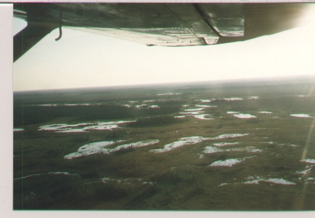
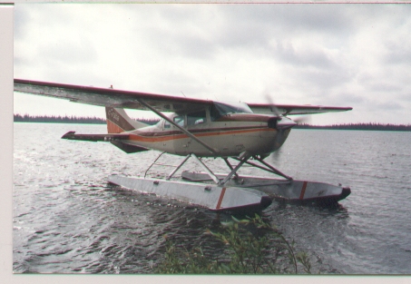
could only hope that the bay had done the same. One hour after our float plane
left Moosonee, we had our first view of Charlton and Darnby Islands.
John, our skilled Cree pilot, made a perfect landing and we soon taxied to
Charlton's shore. We ran into our first problem here - the plane could not get
close enough to shore. Off with the boots, roll up the pants, and Aldo and I
gasped as we jumped into cold water of James Bay. We did managed to pull the
plane closer and then only had to wade up to our numb knees.
After everything was unloaded, our pilot John agreed to try to pick us up
on August 21. That would not happen! After the plane took off, it was a strange
feeling realizing that you were on your own, and the things you had to do to
survive and complete your goals.
Setting up
The first thing that Aldo and I did was to change into some dry clothes.
The temperature was dropping as a northeast wind picked up. The next thing we
did was to move all of the equipment and tents back into the shelter of the
woods. After that, we set up our sleeping tents and our kitchen well away from
the sleeping area , just in case we had some furry visitors.
On previous trips to islands in James Bay and Hudson Bay, we were not able
to find much information on the islands. For this one, we were very fortunate to
have communicated via e-mail with Fred, VE2SEI, who six years previously had
been the first to activate this island. He told us about a spring on the island
and were to find it. This was important information because it meant that we
could bring more equipment and less water and be within the allowable weight
limit in the plane.
Water was the next thing on our agenda. Armed with water jugs and a .308,
we took our first scouting trip, looking for bear signs and the water spring, we
found neither. It was getting near dark, we were tired and would look tomorrow.
The wind increased and rain mixed with snow began as we headed for our
tents. We woke up highly motivated to find the spring. If not, it would be a
long hike to the nearest lake, tough dense bush. Today the wind had died down
and we walked along the same shoreline as the previous night but this time we
were able to hear the noise of falling water. Back in the black spruces, we
found a beautiful little spring, with great testing cold water.
After hauling the water back to the camp, we made a pot of coffee and
cooked up a great breakfast. The frost had just started to melt and, with
renewed energy, we set up our operating tent, placed our generators and battery
charge area downwind, and set up a Hygain TH3JR. on a 35-ft pole, our 6 meter
antenna on a 30-ft pole and strung a 40 meter coaxial dipole, and 80 meter
dipole.
About halfway into setting up, the first squadron of mosquitoes appeared.
Aldo and I were fully prepared and we donned our finest bug jackets and insect
repellent.
CQ de VE8C
With our operating station set up, we called CQ VE8C, and immediately
started a European pileup on 14.260. There were so many stations calling, that
we had to go to split frequency so we could control the pileup. Signals were
very strong on this remote island. Earlier on 80 meters, we were able to reach
Bill, VA3ET, who was able to pass messages on to our families that all was well
and that we were having a great time. Aldo and I took turns working our busiest
band, 20 meters, which only shut down for a few ours at night. On our other rig,
we worked 6 meters, although no major openings occurred, the contacts that we
made on this band were very unusual
We had a chance to work stations using the aurora, which causes the
signals to sound very strange, and the meteor scatter, which produces strong
signals for a short length of time, sometimes only for a second. We heard later
that one of the stations we worked put it on the packet cluster and many
antennas were pointed north.
On the third day, a major solar flare occurred, the band weakened but, we
were able to copy stations in Europe and Asia at very reduced signal strengths.
it actually made it easier for us to pick up the stations call signs out of the
pile up.
40 and 80 Meters were very quiet for this time of year and many contacts
were made on this bands. We also made contacts on 15 but 10 meters was not open.
The hardest part of the operation was getting in and out of the tent without
filling it with mosquitoes. When that happened, we would QRX and splatter them.
Exploring and Hiking
During the height of of the solar flare, Aldo and I decided that it would
be a good time to explore some of the island. We headed inland, past the black
spruces and came to a huge, open sandy area. Here, we found large flocks of
geese and ducks feeding on the blueberry. We joined their feast. Then we angled
toward the shoreline where we found the tide had gone out and exposed huge
boulders and rocks, many with fossils. Large amounts of kelp had washed up,
where we found large jellyfish and small shrimp. Later we would sight a pod of
Beluga Whales.
Walking down the beach we found the old remains of the Hudson Bay Company
Dock. We found out later that The Hudson Bay Company trans-shipment settled
1681-1686 had ben excavated and moved by The Royal Ontario Museum in 1971.
An historic century, a burial cairn, and building traces from the 1900-31
Hudson's Bay Company trans-shipment site were mapped. Charles Town settlement
also existed here from 1831-32 but no traces have been found.
Further down the shore, we found a huge anchor and I could only wonder
what ship could have carried it. In the hunting season, the Cree come here to
hunt and have built some teepees and shacks near the old dock.
Time To Leave
The evening before our departure day, the wind had turned into a gale,
threatening to bend the elements on our tribander. It was a sight to look at the
channel between Darnby and Charlton Islands.
There were huge waves with whitecaps turned to spray by the force of the
wind. I could only imagine the fear that the early explorers felt when at sea in
these conditions. There was no way our float plane could land tomorrow. The
clouds were forming and we were in for some weather. Aldo decided to add an
extra tarp over his tent an action that he would regret. I crawled into my tent
and fell into a deep sleep listening to the heavy rain beating down.
The next morning when I got up, I saw a bagged out Aldo standing over the
coffee pot. It turned out that a bunch of lemmings had decided to play under his
tarp all night.He didn't sleep well with the patter of little feet around him.
It was strange, we had not seen any lemmings and now there were hundreds of them
and about two hours later they all disappeared.
The wind had eased but it was still too strong for a safe landing by the
float plane. We relayed this message and went back to work with the pileup.
The next day was very calm and we radioed this to Moosonee. We were
informed of our pilot's arrival time. With that good news, we packed all of our
equipment, including our garbage, and hauled it near the plane's landing area.
Soon after this, our float plane arrived and with one more numbing wade into
James Bay, we had our plane loaded and were soon on our way back to Moosonee.
We had more than meet our goals on this trip having worked 1602 contacts
with 50 countries in 33 hours of operating.
We have to thank the rest of the Polar Bear Express crew back in Moosonee
that had helped us in many ways via the radio,Bushland Air, Ontario Northlands,
Alinco, and Durham Radio for the equipment and technical support. Thanks also to
the Scarborough and Cobourg ARCs for the loan of their equipment. It was a great adventure, and
a chance to look into and absorb in wonder
some of Canada's historic past.
Copyright 2020 Whitby Amateur Radio Club. All Rights Reserved.